


|
|
|
| |


 |
View the Virtual War Memorial |
|
| NB. - Gloucester Veterans may have lived in any former Gloucester neighbourhood including New Edinburgh, Vanier, Rockcliffe, Overbrook, Alta Vista, Hunt Club, etc. and all parts of the former City of Gloucester | ||
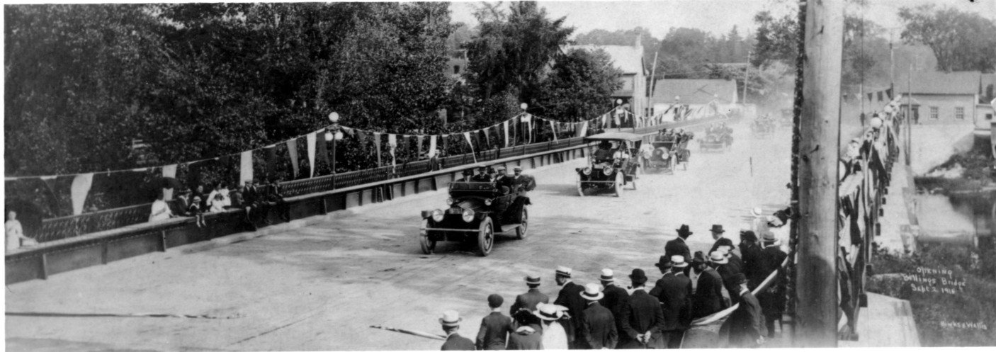
Billings Bridge - The most important entry point from Gloucester
into Ottawa since 1830.
Here we see the current bridge on opening day, September 2, 1915
Photo by Binks & Wallis and supplied courtesy of Library and Archives Canada,
Copy Number C-014138
The Story Behind the Picture
It is the day of the official opening of Billings Bridge, September 2, 1915. A large crowd has gathered including
City engineer Askwith, Gloucester Reeve Caleb Hardy, his council and county officials, and Brad Billings, the so called 'King of Billings Bridge'. The bridge is brightly decorated with red, white and blue cheesecloth streamers and flags borrowed from the Exhibition association. The bridge is roped off at both ends and also decorated in preparation for an official ceremony. Cars are rounded up including the fire chief's car and the mayor's private vehicle. City controllers and councillors and newspapermen are assembled in the cars and they rush south from the city to the bridge. Without getting out of his car, Ottawa Mayor Nelson Porter cuts the rope and drives across the bridge with the other vehicles. After driving a short distance, they turn around and drive north across the bridge with the mayor briefly stopping. He insists that no speeches will be made and he quickly departs. What appears in the photo as a specially scripted event turned out to be totally underwhelming. [Ottawa Journal, September 3, 1915 p.14]
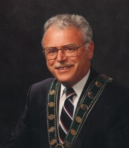
Gloucester Mayor (1985-1991)
(February 27, 1931 - May 14, 2024)
| Neighbourhood | When Part of Gloucester | When Absorbed into Ottawa | Other Comments |
|---|---|---|---|
| Alta Vista | Prior to 1950 | January 1, 1950 | |
| Beacon Hill | Prior to 2001 | January 1, 2001 | |
| Blackburn Hamlet | Prior to 2001 | January 1, 2001 | |
| Blossom Park | Prior to 2001 | January 1, 2001 | |
| Billings Bridge | Prior to 1950 | January 1, 1950 | |
| Borthwick Ridge (The Ridge) | Prior to 2001 | January 1, 2001 | |
| Cardinal Heights | Prior to 2001 | January 1, 2001 | |
| Carlsbad Springs | Prior to 2001 | January 1, 2001 | |
| Carson Grove | Prior to 2001 | January 1, 2001 | |
| Castle Heights | Prior to 1950 | January 1, 1950 | |
| Chapel Hill | Prior to 2001 | January 1, 2001 | |
| Chateauneuf | Prior to 2001 | January 1, 2001 | |
| Convent Glen | Prior to 2001 | January 1, 2001 | |
| Cyrville | Prior to 2001 | January 1, 2001 | |
| Dolman Ridge | Prior to 2001 | January 1, 2001 | |
| Eastway Gardens | Prior to 1950 | January 1, 1950 | |
| Ellwood | Prior to 1950 | January 1, 1950 | |
| Elizabeth Park | Prior to 2001 | January 1, 2001 | |
| Elmvale Acres | Prior to 1950 | January 1, 1950 | |
| Emerald Woods | Prior to 2001 | January 1, 2001 | |
| Ficko | Prior to 2001 | January 1, 2001 | |
| Findlay Creek | Prior to 2001 | January 1, 2001 | |
| Forbes | Prior to 1950 | January 1, 1950 | |
| Gloucester Glen | Prior to 2001 | January 1, 2001 | |
| Greenboro | Prior to 1950 | January 1, 1950 | |
| Hawthorne Meadows | Prior to 1950 | January 1, 1950 | |
| Heatherington | Prior to 1950 | January 1, 1950 | |
| Herongate | Prior to 1950 | January 1, 1950 | |
| Heron Park | Prior to 1950 | January 1, 1950 | |
| Hiawatha Park | Prior to 2001 | January 1, 2001 | |
| Hunt Club | Prior to 1950 | January 1, 1950 | |
| Honey Gables | Prior to 2001 | January 1, 2001 | |
| Kempark | Prior to 2001 | January 1, 2001 | |
| Leitrim | Prior to 2001 | January 1, 2001 | |
| Lindenlea | Prior to 1889 | January 1, 1889 | |
| Long Island (north half) | Prior to 1974 | January 1, 2001 | Ceded to Rideau Township on January 1, 1974 |
| Manor Park | Prior to 1950 | January 1, 1950 | |
| Mooney's Bay | Prior to 1950 | January 1, 1950 | |
| New Edinburgh | Prior to 1867 | January 1, 1887 | Incorporated as a village in 1867 |
| Notre-Dame-des-Champs | Prior to 2001 | January 1, 2001 | |
| Orléans (west part) | Prior to 2001 | January 1, 2001 | Orléans was a semi-automonous Police Village from August 15, 1922 until January 1, 1974 |
| Orléans Village | Prior to 2001 | January 1, 2001 | |
| Overbrook | Prior to 1950 | January 1, 1950 | Overbrook was a semi-automonous Poliece Village from August 15, 1922 until December 31, 1949 |
| Pineview | Prior to 2001 | January 1, 2001 | |
| Piperville | Prior to 2001 | January 1, 2001 | |
| Playfair Park | Prior to 1950 | January 1, 1950 | |
| Quarries (Montreal Road) | Prior to 1950 | January 1, 1950 | |
| Quinterra | Prior to 1950 | January 1, 1950 | |
| Ramsayville | Prior to 2001 | January 1, 2001 | |
| Rideau Park | Prior to 1950 | January 1, 1950 | |
| The Ridge | Prior to 2001 | January 1, 2001 | |
| Ridgemont | Prior to 1950 | January 1, 1950 | |
| Riverside Park | Prior to 1950 | January 1, 1950 | |
| Riverview | Prior to 1950 | January 1, 1950 | |
| Riverside South | Prior to 2001 | January 1, 2001 | |
| Rockcliffe Park | Prior to 1925 | January 1, 2001 | Rockcliffe was a semi-automonous Police Village starting on January 31, 1908. Incorporated as a village in 1925 |
| Rothwell Heights | Prior to 2001 | January 1, 2001 | |
| Sheffield Glen | Prior to 1950 | January 1, 1950 | |
| South Gloucester | Prior to 2001 | January 1, 2001 | |
| South Keys | Prior to 1950 | January 1, 1950 | |
| Southvale | Prior to 1950 | January 1, 1950 | |
| Sundridge | Prior to 2001 | January 1, 2001 | |
| Upper Hunt Club | Prior to 2001 | January 1, 2001 | |
| Urbandale Acres | Prior to 1950 | January 1, 1950 | |
| Vanier (previously Eastview, Janeville) | Prior to December 11, 1908 | January 1, 2001 | Incorporated as the Village of Eastview on December 11, 1908, renamed Vanier on January 1, 1969 |
| Wateridge | Prior to 1950 | January 1, 1950 | |
| Windsor Park | Prior to 2001 | January 1, 2001 |
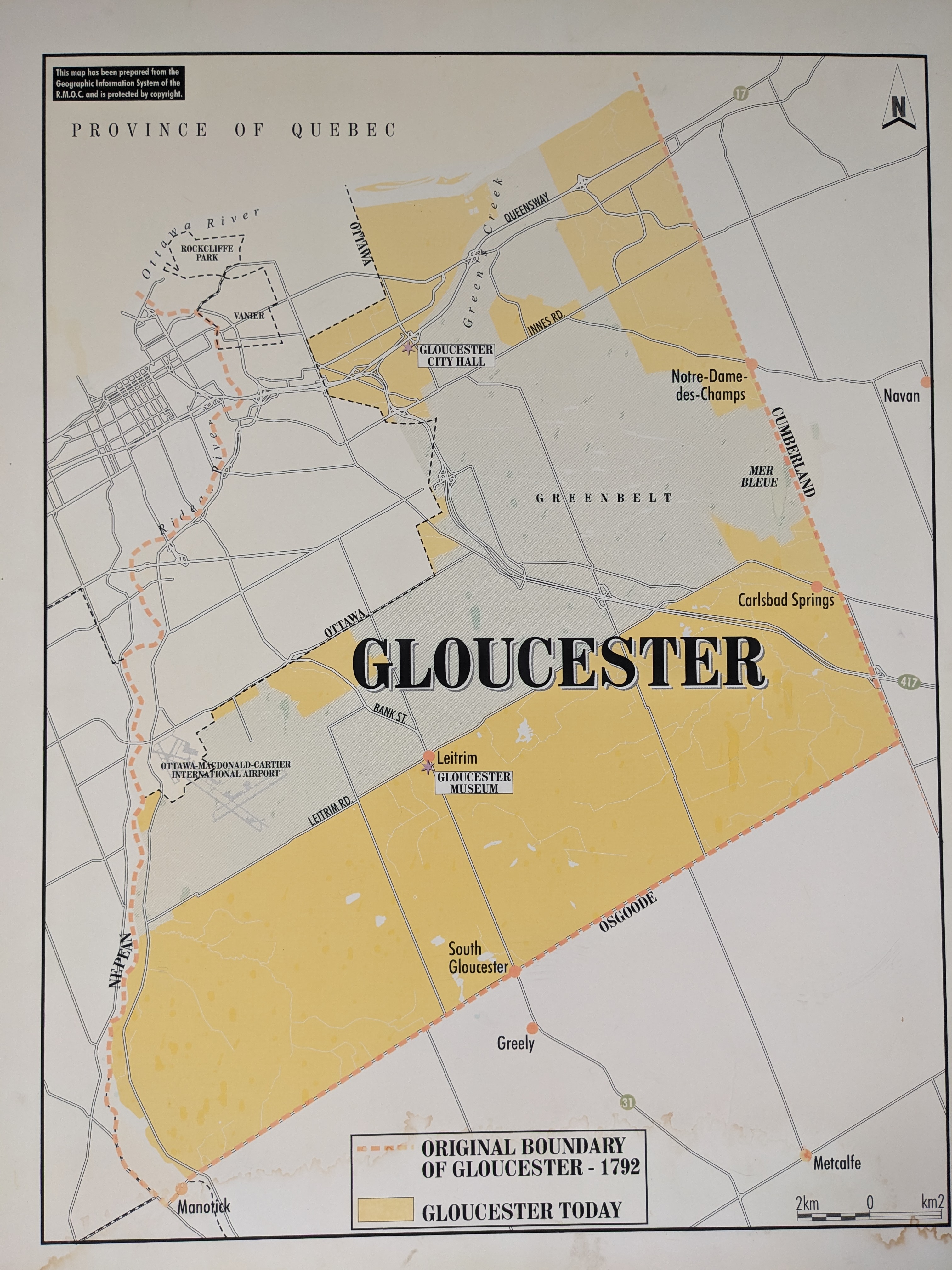
(Click on map for larger version)
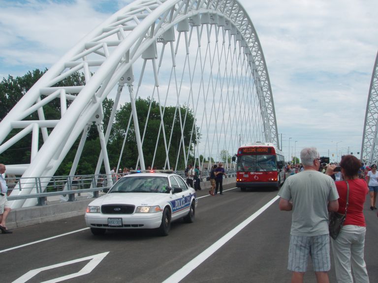
History in the Making - The official opening of the Strandherd-Armstrong Bridge - July 12, 2014. The new Rideau River link between Gloucester and Nepean.
Other Coming Events |
| Next Board of Directors Meeting - The next Board of Directors meeting will take place on Thursday, November 20, 2025 at 6:30 p.m. at St. James Anglican Church, 4540 Bank Street at Leitrim. Visitors are welcome. |
| ||||||
Announcements |
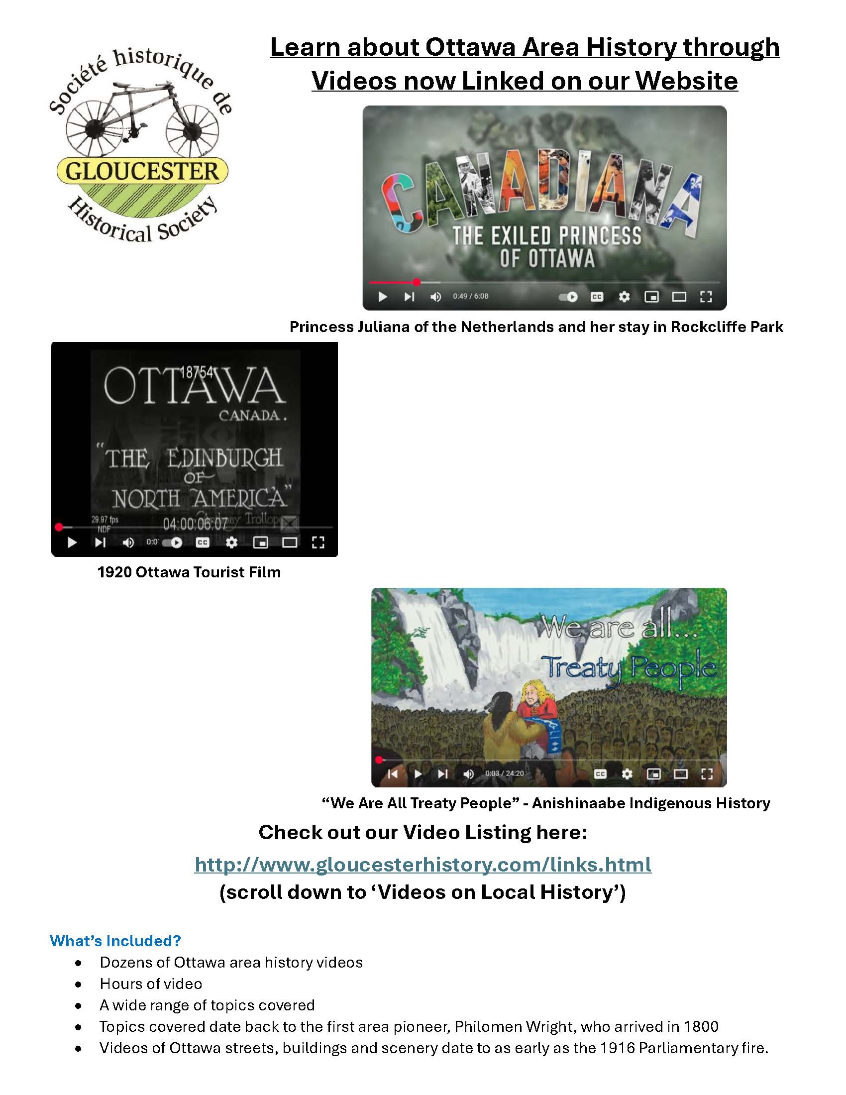
| (February 17, 2025) Our Links page now includes hours of videos including film footage going back to as early as the aftermath of the 1916 Parliamentary Fire and other videos discussing Ottawa history back to our very first pioneer, Philemon Wright. Click here to view list of videos. Scroll down to Videos on Local History |
| (July 31, 2024) You can now see videos on the history of CFB Uplands, the story of the military side of Uplands (Ottawa) Airport, and also a video on the story of 408 (Photographic) Squadron RCAF at Rockcliffe. Click here to view the video on CFB Uplands Click here to view the video on 408 (Photographic) Squadron of the RCAF at Rockcliffe | (July 25, 2024) The Reeves and Mayors of Gloucester, Eastview/Vanier, Rockcliffe Park and New Edinburgh were the leaders of our communities. Countless news stories have now been linked often telling us their life stories including their various accomplishments. One went to the Yukon Gold Rush in the late 1890s. Another was involved in a landmark human rights trial in 1982. Others served in the military, the upper echelons of the Civil Service or moved up to Provincial or Federal politics. Others again operated successful Ottawa businesses. Click here to learn more. |
| (September 13, 2022) Gladys Wicker grew up in Overbrook during the 1930s and 1940s. She was very gracious to share her memories of those days in a video interview which took place in September and October 2020. Click Here to view . |
| (September 13, 2022) Hurdman's Bridge is a Gloucester village that has disappeared, now over 70 years ago. A former crossroads between Russell and Tremblay Roads and Hurdman's Bridge, it was an important entry point into Ottawa and had multiple railway junctions. Here is a story of the Turner family who lived near the bridge. Click Here to view . |
| (December 19, 2020) Did you ever wonder how a street was named? The Gloucester Historical Society has assembled a new list of street names and who or what they are named after. The list is far from complete and we welcome information on any street. Click Here to view . |
| (August 18, 2020) Disasters of the Century. A video documentary about the CF100 crash into the Villa St. Louis, Orléans on May 15, 1956. Click Here to view . |
| (July 2, 2020) The National Film Board's "A Bus - For Us" from 1972. A film about the Beacon Hill Express popularly known as the 'Beacon Hill Bullet'. Click Here . Watch for the old Capital Coach depot on Ogilvie Road, Township of Gloucester sign and Pure Spring delivery truck. This was the trial that led to OC Transpo's express bus network that started in 1974. |
| (January 19, 2020) The Reeves and Mayors of Rockcliffe and Vanier (Eastview) and the Police and Fire Chiefs of Vanier have now been added and can be found here Click here. The lists for Eastview and Vanier have been substantially updated on January 19, 2020 including Clerks and Treasurers. |
| (November 16, 2019) Captain Steven Dieter's presentation on October 27, 2019 titled "From Normandy to the Scheldt, Remembering those from Gloucester Township who fell in duty". This tells the story of Gloucester and Eastview servicemen who lost their lives between November 6 and October 27, 1944. Click here to view video |
| (October 23, 2019) John Saunderson (1936-2018) remembers life at Mooney's Bay and Elmvale Acres. The narrator is Russell Johnston. Video courtesy of Storyline Production. Click here to view video |
| (February 19, 2019) Ontario Land Registry Records are now available on-line. This is an enormous resource for those researching the history of particular properties including houses. In order to use this resource, you will need to know the legal description of the property, such as Concession and Lot numbers or Subdivision Plan and Lot numbers. Remember that Gloucester records are first identified by the Ottawa Land Registry Office. Click here for to Access Land Records |
| (January 20, 2019) Brief School and Church histories have been added to the website. Note: This is a work in progress and will be updated periodically. We welcome your contributions including additional information, donations of school and church histories and photographs. Click here for School Histories. Click here for Church Histories. |
| A video of our 2018 AGM speaker, John D. Reid presenting "A Blast from the Past, Ottawa's Weather at its Worst" . Video courtesy of Storyline Videos. Click here to view video. (October 25, 2018) |
| The Gloucester Historical Society now has digital copies of the Gloucester Photo Collection. Click here for the list of photos in the collection. (February 17, 2018) |
| A video recollection of the Carlsbad Springs spas. Video courtesy of Storyline Productions. Click here to view video. (February 17, 2018) | Family Names for which information is available at the Grace Johnston History Room has now been added here: Click here. (November 18, 2017) |
| Watch David Mowat's Presentation on the Woodburn and Ogilvie families involvement in the Klondike gold rush at the 2016 GHS Annual Meeting. Click here to view the video. (June 18, 2016) The GHS wishes to thank Wasim Baobaid of Storyline Productions for filming, editing and posting this video on the Internet for public access. |
| Learn about Tom Cruise's three year residence in Beacon Hill. Click here for the full story. (July 7, 2015) |
| Links Page fully updated to fix broken links. (May 23, 2015) |
| Publications may now be purchased by credit card through Paypal. (March 21, 2015) Click Here to Order |
| Gloucester Fire Chief and Township Clerk List Added (February 20, 2015) Click Here to View |
| Gloucester Police Chief List Added (February 16, 2015) Click Here to View |
| Gloucester Roots Index Added (February 14, 2014) Click Here to View |
| Newsletter Index Added (January 29, 2014) Click Here to View |
| Carleton County Wardens from Gloucester Added (October 17, 2013) Click Here to View |
| Gloucester History Page Improved - (February 13, 2011) A lot of information has been recorded in the Gloucester historic time-line over the last 5 years but as the time-line has grown more comprehensive, it has also become more difficult to find specific facts and stories. To make it easier, a comprehensive index has been added and navigation links will facilitate moving around the page. Click here to see the latest history page and index. |
| Gloucester Place Names Project - Perhaps, one of the most important research projects in the Society's history. The Society is attempting to identify and assemble all place names, past or present, within the original territory of Gloucester Township and provide some information on each.. This will be an evolving project which will lead to the publication of a book. In the meantime, our research will be appearing on this website. You are welcome to review our Place Names page. |
| Honey Gables - The Gloucester Historical Society is pleased to announce that we are collaborating with a community researcher with the end goal of producing a detailed written history of Honey Gables authored by the community researcher. |
| Volunteers - If you are interested in history, there are opportunities to learn more about your community by helping out in the history room. Please contact us for details. |
| Donations - The Gloucester Historical Society always welcomes donations that preserve Gloucester History. We will accept family histories, community histories, organization histories, church histories, school histories, photographs, historic documents and artifacts. Items of historic significance will be preserved in an appropriate local museum or local archives. If you would like to donate something, please contact us. |
| GHS Newsletters Now On-Line - Click here to view almost every Newsletter published by the Gloucester Historical Society since 1993. |
New Publications |
|
New Publication (October 17, 2015) - Railways of Gloucester - and Beyond! is a 72 page book written by Leslie Goodwin and edited by Joan Scott. This is a follow-up of Leslie's excellent presentation at the 2015 Annual Meeting. The book covers all the railways that once crossed Gloucester Township and includes dozens of photos, many in colour and many that have never been published before. An excellent resource for those interested in local railway history. The price is just $20.00. New Publication (June 28, 2014) - 40 Years of Top Generation Club: 1974-2014 is an 80-page book produced for the June 2014 anniversary of the seniors’ club that was responsible for restoring the one-room Ramsayville School, built in 1894. The school, originally known as Gloucester School Section #13, was abandoned and left at the mercy of vandals in the early 1970s when a group of local seniors saw the potential for putting it to use as their clubhouse. Forty years later it is a designated heritage building in excellent condition that is used regularly by the Top Generation Club and other groups. The book, edited by Laurel Sherrer, features a history of the club and of the schoolhouse written by club member Belma (Alexander) Hull, as well as individual recollections of several long-time club members and others associated with the early days of the club. New Publication (April
21, 2013) - Gloucester A to Z by Robert Serré New Publication (April
20, 2013) - The Emergency Shelters at Finter (Rockcliffe) and
Uplands 1946 - 1954 by Glenn Clark New Publication (February
7, 2013) - Who was Who in Ottawa 1855 - 1967 by Robert Serré,
2013
|
|
Did you know? 13. The current Billings Bridge and Cummings Bridge were both originally designed for streetcars but neither would ever be used for that purpose. 14. Gloucester had two historic airports at Rockcliffe and Uplands, however, the first inter-city airmail flight into Ottawa used neither. That historic flight in 1913 made use of Slattery's Field, in Ottawa East. 15. Do you know which islands in the Rideau River originally belonged to Gloucester and Nepean? Porter's Island, Cummings Island and the north half of Long Island were part of Gloucester. Green Island and Nicholls Island (at Long Island Locks) were part of Nepean. The south half of Long Island was part of Osgoode Township. |
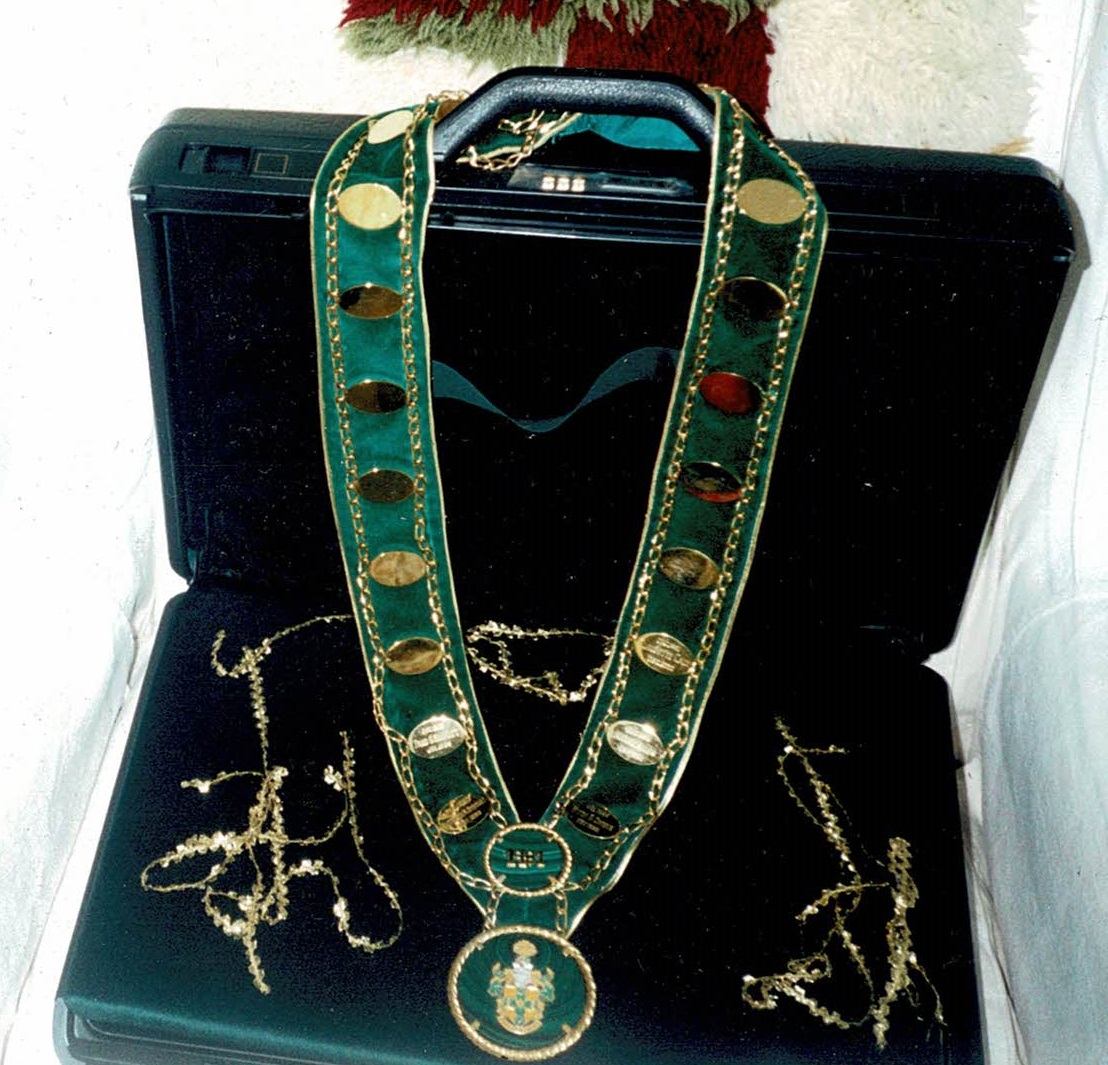
| Picture of
the Month - April 2019 The chain was originally presented to former Gloucester Mayor Harry Allen on March 25, 1988 by page Erinn O’Brien, then age 8 at the Gloucester council chamber. It features 20 gold medals on a green velvet backing with the name of each mayor engraved on the medallions since the city was incorporated in 1981. The bottom of the chain features a 3-inch malachite medallion including a full colour version of the Gloucester Coat of Arms.
AM-TECH Electrical Services The presentation featured a pronouncement by the official town crier and a message by Chamber president Regis Trudel. It was a symbol of the Chief Magistrate of the municipality and was to be worn by the mayor with dignity and respect and as a symbol of integrity, goodwill and fairness.
Former Gloucester Mayor Claudette Coulas (Cain) presented the Chain of Office to Ottawa Mayor Jim Watson on Sunday, April 14, 2019 as part of the Gloucester Historical Society Annual General Meeting.
|
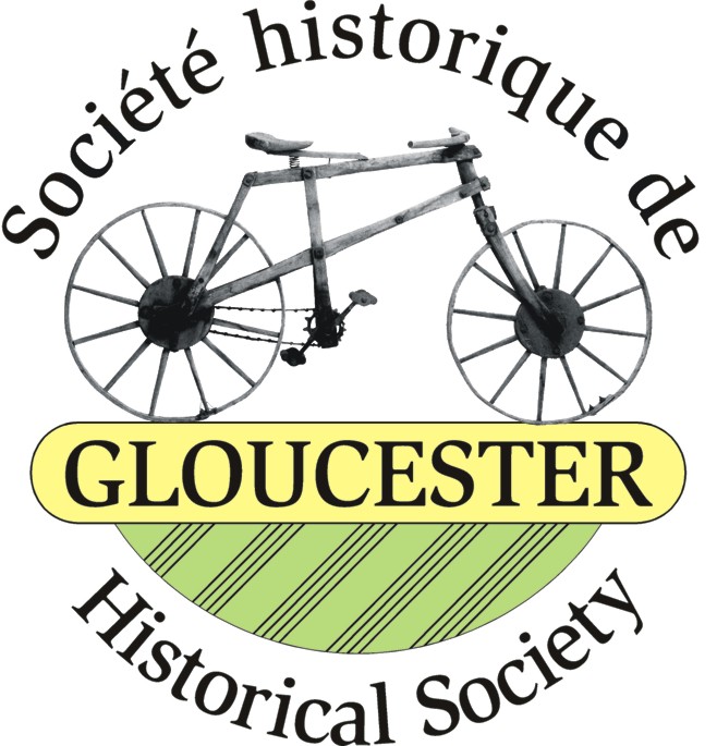
| About the Logo: For many years the Gloucester Historical Society used the wooden bicycle which had been made by 17 year old James Blair in 1898. The official logo as shown above was designed by R.N. Strong, Graphic Designer, who was commissioned to come up with a meaningful design. The original bicycle is incorporated in the design and the colours of the Gloucester Historical Society, yellow and green are used. The green in the part below the word "Gloucester" represents a ploughed field, complete with furrows. |
Last Updated November 19, 2025
 |
The Gloucester Historical Society acknowledges
the financial assistance of the City of Ottawa Copyright © 2011-2025 Gloucester Historical Society. All Rights Reserved. |